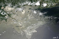
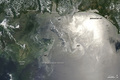
Oil Slick in the Gulf of Mexico
Located squarely in the sunglint part of this photo-like satellite image from Saturday June 26, 2010, the oil leaking from the damaged Deepwater Horizon well in the Gulf of Mexico was easily visible when the Moderate Resolution Imaging Spectroradiometer (MODIS) on NASA's Terra satellite viewed the area.

© Image from NASA's Terra satellite - courtesy of the NASA EO-1 team
Silvery-gray streaks and patches of oil are visible across a wide area. Oil changes the way the water reflects and absorbs sunlight, making the Gulf look brighter in some locations and darker in others. Photo-like images are not a perfect tool for mapping oil slicks, however. Some variations in brightness may have natural causes, such as the muddy, freshwater runoff from the Mississippi River. In addition, oil may be undetectable if it is located outside the sunglint region.
© Earth Observatory
Oil spill
-

Jun 26 2010
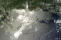
Oil Slick Around Mississippi Barrier Islands
-
Jun 26 2010
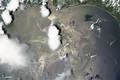
Oil Slick in the Gulf of Mexico
-
Jun 25 2010
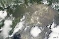
Oil Slick in the Gulf of Mexico
-
Jun 19 2010
Oil Slick in the Gulf of Mexico
-
Jun 18 2010
Oil Slick in the Gulf of Mexico
-
Jun 12 2010
Oil Slick in the Gulf of Mexico