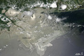
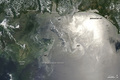
Oil Slick in the Gulf of Mexico
On June 12, 2010, oil from the still-leaking Deepwater Horizon well was particularly visible across the northern Gulf of Mexico when the Moderate Resolution Imaging Spectroradiometer (MODIS) on NASA's Aqua satellite captured this image at 1:55 p.m. Central Daylight Time. Oil appears to have reached beaches and barrier islands in Alabama and the western Panhandle of Florida.

© Image from NASA's Terra satellite - courtesy of the NASA EO-1 team
Close to the location of the well, the oil appears gray, but to the northeast, it is bright silver. The increased brightness does not necessarily mean the oil is thicker or more concentrated there; it may simply be that the oil is located in the sunglint region of the image-the spot where the Sun's reflection would appear if the water surface was as perfectly smooth as a mirror.
Normally, waves blur the Sun's reflection, diffusing its brightness. Oil smoothes the water surface, making it a better mirror. When the slick appears in that part of the image, viewing conditions are ideal, and the patches and ribbons of oil are extremely bright. When the oil slick is not in the sunglint part of the image, however, it may be imperceptible against the dark background of the ocean.
© Earth Observatory
Oil spill
-

Jun 26 2010
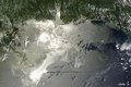
Oil Slick Around Mississippi Barrier Islands
-
Jun 26 2010
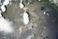
Oil Slick in the Gulf of Mexico
-
Jun 25 2010
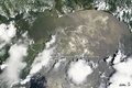
Oil Slick in the Gulf of Mexico
-
Jun 19 2010
Oil Slick in the Gulf of Mexico
-
Jun 18 2010
Oil Slick in the Gulf of Mexico
-
Jun 12 2010
Oil Slick in the Gulf of Mexico