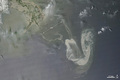
Oil Slick in the Gulf of Mexico
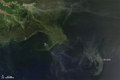
An oil slick remained in the Gulf of Mexico on May 10, 2010, not far from the Mississippi Delta. The Moderate Resolution Imaging Spectroradiometer (MODIS) on NASA's Terra satellite captured this photo-like image of the slick at 11:35 a.m. local time (16:35 UTC) the same day.

© Image from NASA's Terra satellite - courtesy of the NASA EO-1 team
Thin, wispy clouds partially obscure the satellite sensor's view of the ocean surface south of the Mississippi Delta, but oil on the water's surface is still apparent southeast of the delta. The most obvious portion of the gray-beige slick arches toward the west, with inward-curling tendrils.
© Earth Observatory
Oil spill
-

May 17 2010
Oil Slick in the Gulf of Mexico
-

May 11 2010
Oil Slick in the Gulf of Mexico
-
May 10 2010
Oil Slick in the Gulf of Mexico
-
May 09 2010
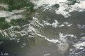
Oil Spill Continues in Gulf of Mexico
-
May 08 2010
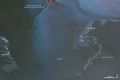
Oil Slick near the Mouth of the Mississippi
-
May 08 2010
Oil Slick in Gulf of Mexico