Oil Spill Continues in Gulf of Mexico
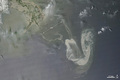
On May 9, 2010, oil continued to flow from a damaged offshore oil well in the Gulf of Mexico. This image from the Moderate Resolution Imaging Spectroradiometer (MODIS) on NASA's Aqua satellite shows the slick on Sunday afternoon.

© Image from NASA's Terra satellite - courtesy of the NASA EO-1 team
The most concentrated part of the slick appears as a silvery, distorted U-shape in the right-hand side of the image. In the north-south direction, the longest part of the U stretches 86 kilometers (53 miles); from east to west, the U is about 54 kilometers (34 miles) wide. Tentacles of oil (faint gray) reach out from the main slick toward the west (52 kilometers, or 32 miles) and north-northwest (46 kilometers, or 29 miles).
© Earth Observatory
Oil spill
-

May 17 2010
Oil Slick in the Gulf of Mexico
-

May 11 2010
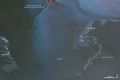
Oil Slick in the Gulf of Mexico
-
May 10 2010
Oil Slick in the Gulf of Mexico
-
May 09 2010
Oil Spill Continues in Gulf of Mexico
-
May 08 2010
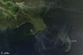
Oil Slick near the Mouth of the Mississippi
-
May 08 2010
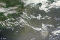
Oil Slick in Gulf of Mexico