Oil Slick in the Gulf of Mexico
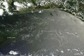
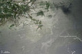
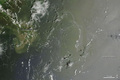
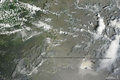
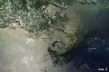
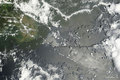
Oil continued to float across the Gulf of Mexico around the Mississippi River Delta in early July 2010, three months after a deadly explosion at an offshore drilling rig. This photo-like image of the region was captured by the Moderate Resolution Imaging Spectroradiometer (MODIS) on NASA’s Terra satellite on July 9.

© Image from NASA's Terra satellite - courtesy of the NASA EO-1 team
The sunglint region of the image—the washed-out area where the Sun’s reflection would appear if the water were as calm and smooth as a mirror—is located in the left-hand side of the view. Oil located very close to the spot where the Sun’s reflection would have appeared in this image looks very bright.
Beyond the area where the Sun’s reflection would have appeared, however, oil may make the water surface look unusually dark rather than bright. The dark arc in the water east of Timbalier Bay may also be oil; it is consistent with oil locations identified with radar images of the area captured on July 8.
© Earth Observatory
Oil spill
-
Jul 30 2010
Oil Slick in the Gulf of Mexico
-
Jul 20 2010
Oil Slick in the Gulf of Mexico
-
Jul 11 2010
Oil Slick in the Gulf of Mexico
-
Jul 09 2010
Oil Slick in the Gulf of Mexico
-
Jul 06 2010
Oil Slick in the Gulf of Mexico
-