UK Forecast- May 04, 2024
Cloud building
Mild and showery
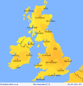
 Sunday
A bright and sunny start for those in central regions on Sunday morning. A few sunny spells across southern Ireland too. Cloudy elsewhere, with a few showers along western coasts, and in Northern England and Scotland. Showers spreading further inland in the southwest as the day progresses. Persistent showers in central Scotland, and a few in Northern Ireland. Cloud building. Feeling mild, with highs of 17C in the south and 16C in the north.
 SundayNight
Rain across central and southwest England, as well as central Wales, Northern England, and Scotland. Wet too across Ireland, and largely overcast for all in the British Isles. Temperature lows of 6C in the south, and 8C in the north.
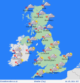 Monday
Rather cloudy through Monday morning over many areas. There will be showery outbreaks of rain for England and Wales. These turning heavy into the afternoon. More scattered showers further south. Cloud and some showers for northern England and Scotland in the morning, turning heavier and more persistent away from coasts, possibly thundery too. A few showers for eastern Ireland but fair in the west. Highs at 18C in England and Wales, and 14C in Scotland and Ireland.
 Tuesday
A cloudy day on Tuesday with some showers in southeast England and Scotland. As the day progresses, patchy showers spread to northern England, perhaps turning heavy at times. A few breaks in cloud in the south. Staying dry in Ireland. Highs of 18C in the south, and 9C in the north.
Ishani
|

